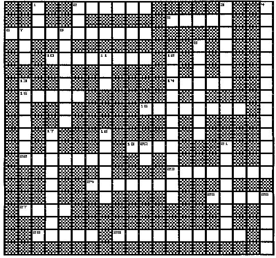
-
2. Topographic maps give an ------ perspective or view of the land.
-
5. Large areas of blue on a topographic map indicate -----.
-
6. Type of map which expresses the relief of a landscape, using a 2-dimensional
(flat) format.
-
10. Standardized unit of land used by the U.S. Land Office, shown on nearly
all topographic maps.
-
14. A topographic feature indicated by a pattern of V-shaped contour lines
pointing upstream.
-
15. Boundary lines which run north and south, marking off east and west
of a map.
-
16. The reference elevation for all contours (elevation equals "zero")
is at --- ----- (2 words).
-
19. Length x Width = ?
-
22. An imaginary line on a topographic map, connecting all points of the
same elevation.
-
23. Parallel boundary lines which divide north and south regions on a global
map of the world.
-
24. Lines which indicate a depression rather than a hill; appear as "teeth"
inside contour lines.
-
25. The standard color used for contour lines on topographic maps.
-
27. The standard color used for water bodies on a topographic map.
-
28. A land surface in which there are theoretically no contour lines is
classified as -----.
-
29. A topographic map which covers a "square" area of land (by reading
longitude and latitude coordinates.)
|
-
1. A representation of land on a planar surface, using an established scale.
-
2. Topographic maps show the land as viewed from the ---.
-
3. A cross-sectional view of the surface topography of the land, as specified
by a section line.
-
4. Map scale where the units between map and land are identical; a ratio
where no units are used.
-
7. The surface area (in square miles) covered by a single section within
a township.
-
8. Type of map encompassing topographic features as well as the underlying
bedrock.
-
9. A measure of the slope of the land; usually as the elevation difference
divided by map distance.
-
11. The length (North-South distance) or width (East-West distance)
of a township, in miles.
-
12. A pattern of contour lines in which the "V" points toward higher elevation
indicates a ------ ------ (2 words).
-
13. Type of map scale which is drawn out as a bar or ruler, located at
the bottom of a topographic map.
-
17. Boundary lines on a world globe which converge at the north and south
poles, subdividing East-West.
-
18. Map scale which usually (but not always) involves different types of
units between map and land (2 words).
-
20. Type of scale in which the units between map and land are the same
type (abbreviation for 2 words)
-
21. The elevation difference between any 2 adjacent contour lines.
-
26. The standard reference direction for all maps; top of the map indicates
-----.
|

