Earth Science Laboratory
USING TOWNSHIP & RANGE COORDINATES WITH TOPOGRAPHIC
MAPS
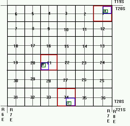 |
Follow the color coding of the coordinates below and match them with
the diagram at the left (Note: this only works if you are viewing this
document on-line or if you have a color hard copy). Using the
township and range coordinates system, the points on the grid are located
as follows:
Point A is located at "SW 1/4 of NE
1/4 of Section 1, T20S, R7E"
Point B is located at "NW 1/4 of SW
1/4 of Section 21, T20S, R7E"
Point C is located at "SW 1/4 of SE
1/4 of Section 34, T20S, R7E"
|
The township and range grid system is
based upon subdivisions of a single township, which is a
square parcel of land that is 36 square miles in area (6 miles North-South
X 6 miles East-West). The boundary lines that run east-to-west, dividing
North from South are called township lines. The boundary lines running
north to side and divide East from West are called range lines.
The township and range coordinates of adjacent townships depend upon the
context of the existing township and range lines. In the above example,
the detailed township is located within T20S, which begins at Section 1
and ends at Section 36. The township to the south is T21S, while the township
to the north is T19S because it is closer to the T-Zero line. Similarly,
the township is located within the range R7E; walking further east causes
the range numbers to go up, while walking west causes them to decrease.
Subdividing a section: A township is divided up into 36
sections,
each of which is 1 square mile (1 mile X 1 mile). Note that Section
1 is always located in the northeast corner of a township, that
Section
36 is always located in the southeast corner, and that the section
numbers zig-zag, East to West, within a township. Although only
one township is shown above, there are 8 other townships located on all
sides of the perimeter boundary. Therefore, the section numbering system
of every other township repeats itself in similar fashion. You must subdivide
a section twice; first, divide the section into quarter sections, then
select one of the quarter sections and subdivide it one more time. The
correct
sequence of location data begins with the smallest location.
Draw a one-mile section measuring template on tracing paper:
To subdivide a section on a topographic map, use a sheet of tracing paper
and a pencil. First, take the corner of the tracing paper and mark off
1 mile along one edge along the graphic scale located at the southern part
of your map. Then, measure 1 mile along the other edge of the tracing paper.
Use a straight edge to draw a box from the 1 mile markings, subdivide it
into quarter sections, and subdivide the quarter sections. A similar
section measuring template may also be made from an overhead transparency
rather than tracing paper.
Copyright ©1996 by William K. Tong
